FsGoogleEarthView enables Flight Simulator VFR flight with realistic Google Earth view!
With FsGoogleEarthView, you can take both :
- Google Earth's great photoreal ground, 3D Buildings, detailed terrain mesh
(No need of FS's ground textures or autogen buildings)
- Flight Simulator's great flight model, flight instruments, add-on aircrafts, add-on airport sceneries
with no downloading and very short loading time, anywhere in the world!
It will provide more enjoyable VFR flight than any other sceneries.
Now with v3.0, additional functions such as VDGS, Landing Report, Airport Moving Map, Route and log management are also included.
It works with FSX, FS2004, Prepar3d, X-plane all.
<Features>
1. FsGoogleEarthView functions, running with the original Google Earth.
2. VDGS (Visual Docking Guidance System)
Enter airport ICAO code (or press Auto Detect button), select gate,
and when you approach the gate, VDGS will be displayed.
(Please refer to http://planeman-fs.blogspot.kr/2012/04/vdgsvisual-docking-guidance-system-for.html)
* VDGS can NOT be displayed if FS is in full-screen mode.
Please switch to window mode by pressing "Alt+Enter".
3. Landing Report
Displays landing report which contains
- V/S at touchdown
- Distance from runway threshold at touchdown
- Deviation from runway centerline at touchdown
- IAS
- Pitch
after landing and decelerating below 15kts.
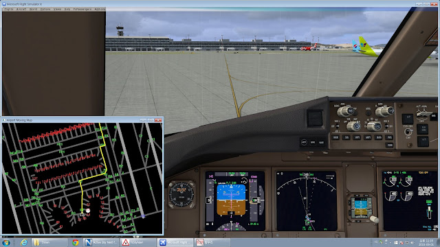
4. AMM (Airport Moving Map) or OANS (On-board Airport Navigation System)
 Enter airport ICAO code (or press Auto Detect button),
and press "Show Moving Map" button to display map.
Use mouse wheel to zoom in/out, and right click to toggle center mode.
Select destination runway or gate to display taxi path. (Sometimes it can be different from taxi path of FS.)
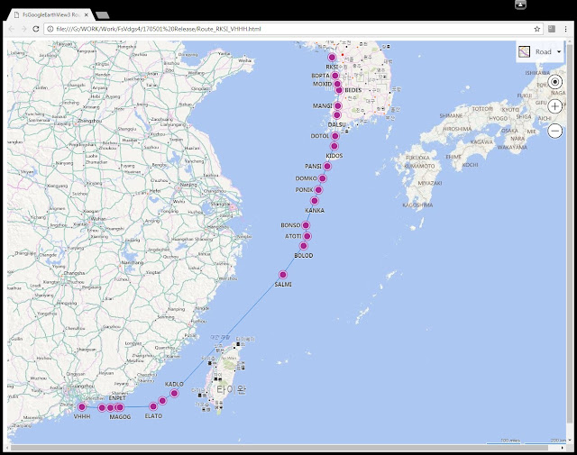
5. Route Visualization
 Route (Flight plan) can be visualized with Google Earth and Bing Map.
Press "Route/Log Management", enter route,
and press "Convert Route" button to generate KML/HTML files.
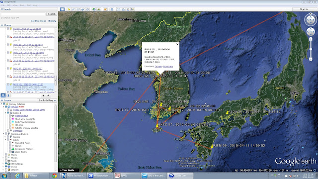
6. Flight Log
If you run FsGoogleEarthView before the departure, and finish flight using VDGS,
Departure Log, Landing Report, and Parking Log is automatically saved in "FlightReport.txt" file.
Press "Route/Log Management" and "Open Log" button to read.
Log Example)
@ 2015-08-09 13:26:56
Departed at (13.690823, 100.745429)
@ 2015-08-09 14:22:16
Landed on VTSP 27 (8.113768, 98.323144)
V/S=178fpm, Lateral Dev.=2ft, T/D Dist.=2556ft, Sideslip=-0.2deg, IAS=136.9kts, Pitch=2.8deg
@ 2015-08-09 14:31:44
Parked at gate 8 (8.108479, 98.304617)
 Press "Convert Log to KML" button to see log in Google Earth.
<How to install>
1. Unzip FsGoogleEarthView30.zip to any folder.
Rename FsGoogleEarthView30.ex_ to FsGoogleEarthView30.exe if needed.
2. FSUIPC for FSX or P3D (http://www.schiratti.com/dowson.html) should be installed.
3. Download MakeRwys utility (http://www.schiratti.com/dowson.html), run it in FS folder,
and copy your r4.csv, t5.csv, g5.csv into FsGoogleEarthView folder (overwrite the original files).
4. Google Earth (http://earth.google.com) should be installed.
5. In Google Earth, open "Tools" menu - "Options".
In "Navigation" tab, set "Fly-To Speed" to "4.5". (4.0 to 5.0 is recommended.)
In "3D View" tab, setting "Graphics Mode" to "OpenGL" and
"Anisotropic Filtering" and "Antialiasing" to "High" is recommended for better graphics.
(Please refer to "Google Earth Options 1 and 2.jpg")
6. To use with X-plane, data output should be set.
Select "Data Input & Output" in Settings menu, and in "Data Set" tab,
Check 1st column (Internet via UDP) of "speeds", "Mach, VVI, G-load", "pitch, roll, headings", "lat, lon, altitude".
Then select "Net Connections" in Settings menu, and in "Data" tab,
enter "127.0.0.1" at IP address and "49010" at port.
(Please refer to "X-Plane Data IP.jpg" and "X-Plane Data Output.jpg")
7. When FsGoogleEarthView is launched for the 1st time, Windows Security Alert can be displayed.
Please allow all network access to connect with Google Earth.
<How to run>
1. Run "FsGoogleEarthView30.exe" before or after launching Flight Simulator.
2. Run (by double-clicking) "fsgearthview_master.kml" file. It should be open with Google Earth.
Default "fsgearthview_master.kml" runs at 2 frames per second.
There are other KML files which can run at 5fps or 10fps. You can use them if your PC has enough performance.
3. [IMPORTANT] In sidebar of Google Earth (If you can't see sidebar, select "View" menu - "Sidebar"),
Right click on "fsgearthview_master.kml" in "Temporary Places" in "Places" menu, and select "Delete".
(Please refer to "Delete KML file.jpg")
Then run "fsgearthview_master.kml" file again.
I don't know why, but the connection between Google Earth and FsGoogleEarthView can be only done at 2nd try.
4. Enjoy flight!
There are some useful hotkeys:
- Ctrl+Shift+Z : Look 45 degrees left(in front view) or look from lower(in ground view)
- Ctrl+Shift+X : Look 45 degrees right(in front view) or look from upper(in ground view)
- Ctrl+Shift+C : Switch camera (front view / ground view)
- Ctrl+Shift+V : Switch window between Flight Simulator and Google Earth.
<History>
- FsGoogleEarthView 1.x (March 2013) : Shareware (Paid users can unlock fps limit). Purchase not available since 2015, because Google terminated support for Google Earth API in 2016.
- FsGoogleEarthView 2.0 (May 2016) : New version without use of Google Earth API. Released only for FsGoogleEarthView 1.x paid users.
- FsGoogleEarthView 3.0 (May 2017) : Many additional functions such as VDGS, Landing Report, Airport Moving Map, Route and log management are included. And it's all free!
Please mail me if you have problems or feedbacks.
Thank you!
Dongjin Shin
<Download Link>


